pp. 14-34
Abanish Kumar1, Ankita Bhardwaj1, Pramod Kumar2 and Hitendra Padaliya2
1Jiwaji University, Gwalior, 2Indian Institute of Remote Sensing, Dehradun.
Corresponding email: abanish.sharma@yahoo.com
ABSTRACT
Under the micro-watershed planning and development project of Ministry of Rural development (GOI), many micro-watersheds have been identified for planning and management. In most of the places, the availability of water is dependent on rainfall. Nagani watershed in Tehri-Garhwal, district of Uttarakhand is one of the watershed identified under the micro-level watersheds planning and development programme. The present study has been carried out to plan water and land resources management activities in this watershed. The study area of 76.1 sq km lies between 30°18′23″ to 30°25′17″ North latitude and 78°15′17″ to 78°24′28″ East longitudes covering 17 micro-watersheds. The study has been carried out using Remote Sensing (RS) data obtained from IRS-P6, LISS-IV sensor data of 06th October 06, 19th January 07, 17th March 07 and Ortho image of Cartosat-1 Satellite. From these Satellite data, various thematic maps of drainage, landuse/landcover, geology, hydro-geomorphology, slope, aspect, soil, base maps etc. were prepared. These maps were prepared using ERDAS imagine and Arc GIS software. ERDAS Imagine software was used for data loading and image processing or classification and GIS software’s, Arc Info and Arc Map were used for digitization, editing and for the preparation of final maps, and by integration of all these maps, Action plan maps have been delineated. Thus, the land and water resources action plans generate in the present study will be helpful for sustainable development of natural resources in the region.
INTRODUCTION
WATER is a precious natural resource and at the same time complex to manage. Due to the ever-increasing demand on water resources, the pressure on its judicious utilization is also increasing. Besides being precious, this resource is also complex to manage on account of its dynamic behavior. In a place like India, where emphasis is being placed on making the local level users participate in the management of natural resources at the watershed level (A.K. Gosain et al. 2004). Indias Geographical areas drained by various rivers, among them the Ganga is the main river of Himalayan region in India. Northern region and central Himalayan region are drained by Gangas and its various tributaries. Many cities and towns which are settled beside the rivers their water requirement depend on those rivers and Agriculturer productivity also dependent on various rivers in rural areas. Present study for micro-watershed planning is Nagani river watershed, which is the tributaries of Henval river, is located on Tehri-Garhwal, district of Uttarakhand stat, India. For micro-watershed planning conventionally Field survey are required but Remote Sensing (RS) & Geographical Information System (GIS) techniques are very useful because remote sensing satellites provide synoptic view and high resolution large scale satellite data which are required for micro-watershed planning and GIS techniques are used for integration of data, query, analysis and final maps preparation. In the present study we used LISS-IV sensor data of IRS-P6 satellite and Cartosat-1 (ortho image) data.
Micro-Watershed Planning
Planning and development of micro watersheds calls for rigorous understanding about the occurrence and movement of water in the surface and sub-surface systems along with soil and nutrient losses in a small watershed, as the need arises for a proper watershed management of that area (Suvrokamal Dutta 2007). Micro-Watershed must be considered as a scope of planning under a social, economic and operational approach, besides the territorial and hydrological approach traditionally considered. Thus, the micro watershed is defined as “a small first or second class watershed, (which covers 100 to 1000 hectare area of the Earth surface) in which a certain number of families live (Community) making use and managing the resources of the area, mainly the soil, water, vegetation, including crops and native vegetation, and fauna, including domestic and wild animals (Jan Van Wambeke et al.).
Watershed
“A watershed is a drainage area on earth’s surface from which runoff resulting from Precipitation flows past a single point into a larger stream viz., a river, a lake or an ocean” (P.K. Suresh Kumar 2002). A watershed could be described as fan shaped (near circular) or fen shaped (elongated). Hydrologically the shape of the watershed is important because it controls the time taken for the runoff to concentrate at the outlet.
Watersheds may also be categorized as hill or flat watersheds, humid or arid watersheds, red soil watershed or black soil watershed based on criteria like soil, slope, climate etc. Depending on the land use pattern watershed could again be classified as highland watersheds, tribal settlements and watersheds in areas of settled cultivation (P.C. Jain et al. 2004).
Watershed is a hydrological unit bounded by natural ridges and allows the run- off due to rainfall to drain in a well-defined drainage pattern of streams flowing within the watersheds boundary. As an integral part of area development programme, land resources development programmes are taken up on micro watershed basis as the shape of the watershed controls the natural resources like water, soil and productivity of the land for successful implementation of agriculture, forest and other eco-restoration programmes (S. Mohamed Ghouse et al. 2004).
Types of Watershed
Watersheds could be classified into a number of groups depending upon the mode of classification. The common modes of categorization are the size, drainage, shape and land use pattern. The categorization could also be based on the size of the stream or river, the point of interception of the stream or the river (P.C. Jain 2004). Watershed can be classified into following types: For micro- watershed planning input requirement are high resolution satellite data, Topographic data, Field survey data of study area, other secondary data such as census data of population which are living in watershed
areas, villages information of the area Water level and quality maps, climate, rainfall data etc. and some watershed parameters also required such as:
- Size of the watershed area
- Shape of the watershed
- Physiography of the watershed
- Climate of the watershed area
- Drainage patterns of the watershed
- Land use patterns of study area
- Vegetation covers of watershed area
- Geology and Soils of watershed area
- Hydrology of the watershed area
- Hydrogeology of the watershed area
- Socioeconomic information of the watershed
Table-1. Watershed sub-classification
| 1) Macro watershed (> 50,000 Hect) |
| 2) Sub-watershed (10,000 to 50,000 Hect) |
| 3) Milli-watershed (1000 to10000 Hect) |
| 4) Micro watershed (100 to 1000 Hect) |
| 5) Mini watershed (1-100 Hect) |
STUDY AREA
Tehri-Garhwal is situated in Uttarakhand around 395 km from Delhi and around 60 km from Dehradun. In the Tehri- Garhwal district, the Nagani watershed forming a unique geomorphic unit in Garhwal Himalayas lies in lesser Himalaya in the north and Siwalik in the south and is transversely bordered by the Ganga in the south east and Yamuna in the north west and the Nagani river in the central part of the district. The study area of Nagani watershed lies between 30°18′23″ to 30°25′17″ North latitudes and 78°15′17″ to 78°24′28″ East longitudes. The Nagani river confluence with the devi-nala river at village Devnagar in Tehri district and gives birth to river Henval. The study area covers 17 micro-watersheds and an area of 76.1 sq km. The altitude in this watershed ranges from 511 m to 2722 m above MSL. Physiographically, the area comprises of high relief, deeply dissected topography. The mostly found drainage patterns are dendritic, subdendritic and parallel drainage patterns. High slopes are abundant in the area. The landuse in the study area comprises reserved forest mainly open mixed jungle in the northern, northern east and southern east portion, afforested area in the middle part and rest of the area is mostly agricultural field. The climate of the area is generally temperate. It varies generally from tropical to severe cold depending upon the altitude of the area. The district being hilly, temperature variations due to difference in elevation are considerable. The annual rainfall in this region varies from 1000 mm to 1400mm (annual average of 1200mm) and most of the rainfall (80% to 90%) occurs during June to September month. Geologically the rocks occur in two belts in the northern boundary of the synclinal through viz, Jaunsar (Manhole limestone, Champur phyllite and Naghat quartzite), Intrakrols, Balaini boulder bed and the Krole (limestone and shales). The central part of the district consists of Garhwal Grables, while the southern part of the area is composed middle and upper Siwalik (sandstone and shales).
DATA USED AND METHODOLOGY
In the present study, multi-sources and temporal satellite images have been used along with other secondary data such as topographic maps, census data for preparing land and water resources action plans using Remote Sensing and GIS techniques.
Used data
For this study different date of IRS- P6, LISS-IV sensor data have been used: 06 October 2006 image, 19 January 2007 image and 07 March 2007 image and Topographic maps on 1:25,000 scale. Ortho-image and DEM of Cartosat-1 satellite have been also used. Other required data such as geological map, hydro-geomorphological map, soil map, slope map, aspect map, drainage map, well location map, block information, Land information, etc. of the study area have been also used, and some of above data like ortho image, DEM, geological map, hydro- geomorphological map, soil map, well location, block information, land information map have been provided by RRSSC- Dehradun, and such maps had been prepared by this organization in their previous study of this study area.
Methodology
For this study there were various operations performed for the generation of different thematic maps, and suitable action plans for Micro-watersheds. Ortho rectification procedure has been used for image registration and for image classification, object based classification (segmentation) techniques has been used. Ecognition software of definion has been used for segmentation of ortho image by applied multi-scale segmentation method then find out land use/ land cover classes for both season (Rabi & Kharif) by attribution of segmentation layer by visual interpretation of satellite imageries. For the classification of forest type & forest cover, altitude based classification technique has been applied by using cartosat-1 DEM. Other recourses maps also prepared such as, drainage map, slope map, aspect map, base map of the study area, by using Erdas & Arc GIS software’s. For watershed and micro-watershed boundary delineation first we had digitized watershed boundary by using Arc GIS 9.2 software, then 3D correction procedure also applied for gating correct watershed boundary of study area by using Leica Photogrammetric Suit (LPS) software. Two action plan have been prepared for Land resources development activities and water resources development activities by integration of all.
Flow Chart for Methodology
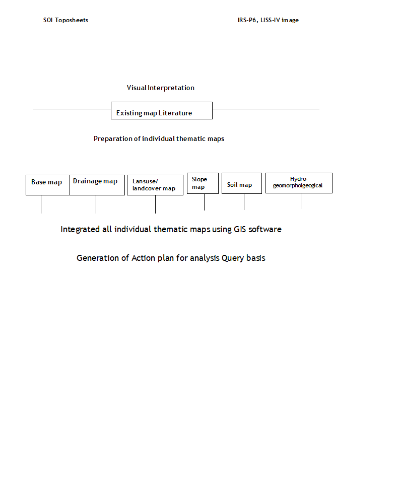
FIGURE-1: Location map of study area.
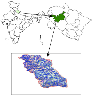
FIGURE-2: Ortho image of study area.
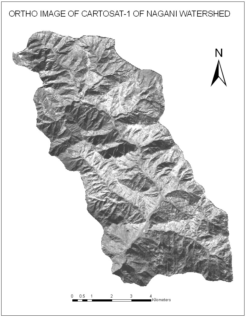
FIGURE-3: LISS-IV image of October of study area.
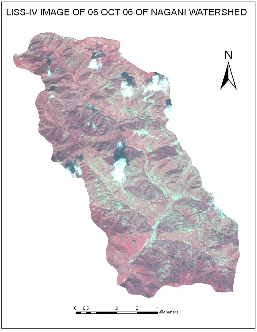
FIGURE-4: LISS-IV image of January of study area.
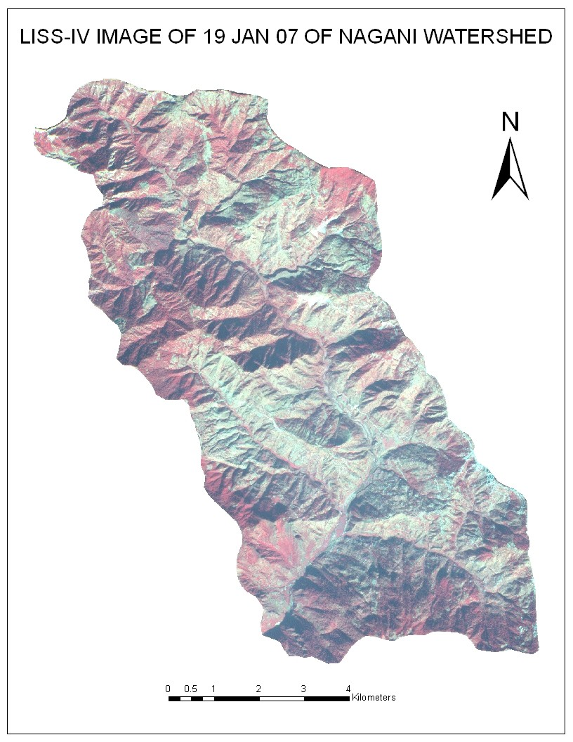
FIGURE-5: LISS-IV image of March of study area.
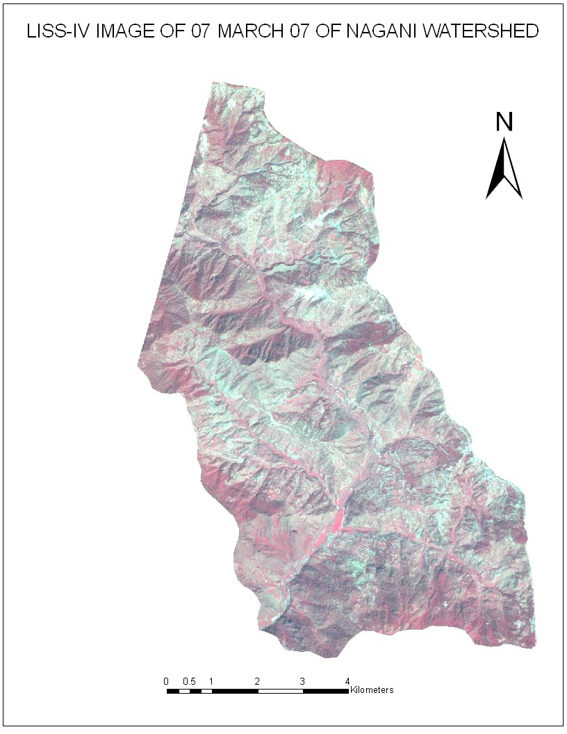
FIGURE- 6: Landuse/Landcover map of study area.
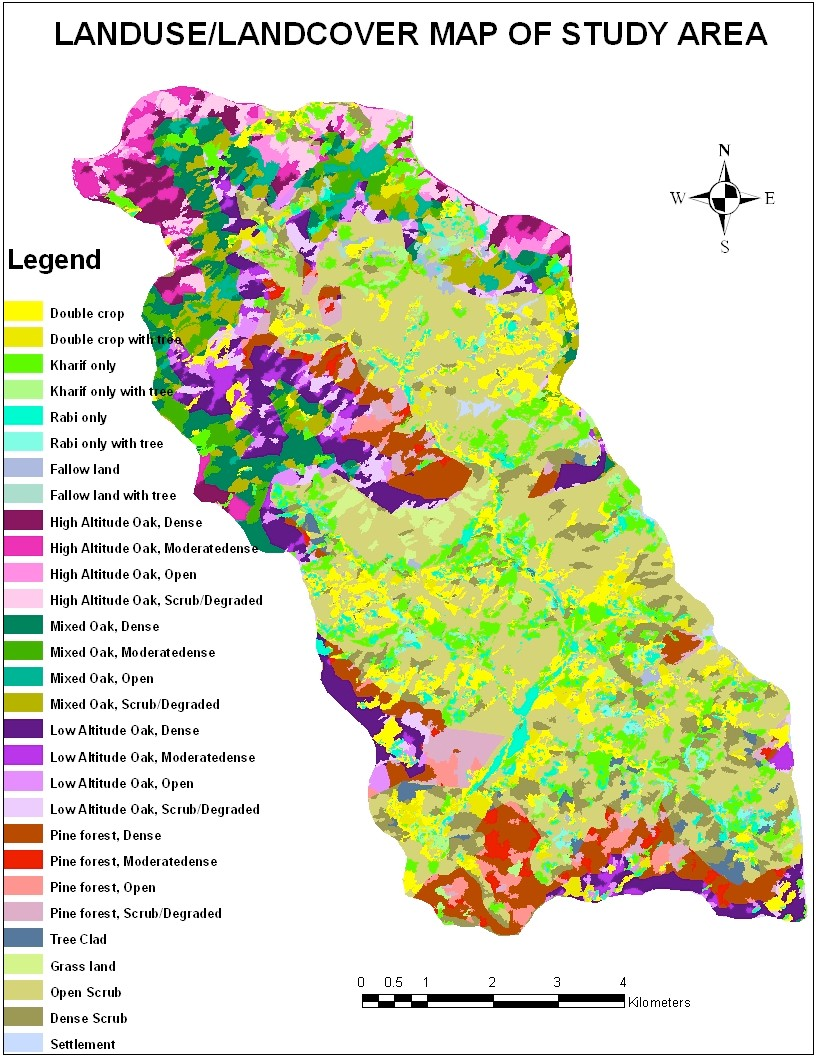
FIGURE – 7: Action plan for land resources development.
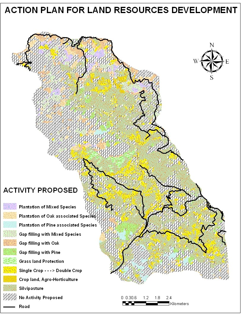
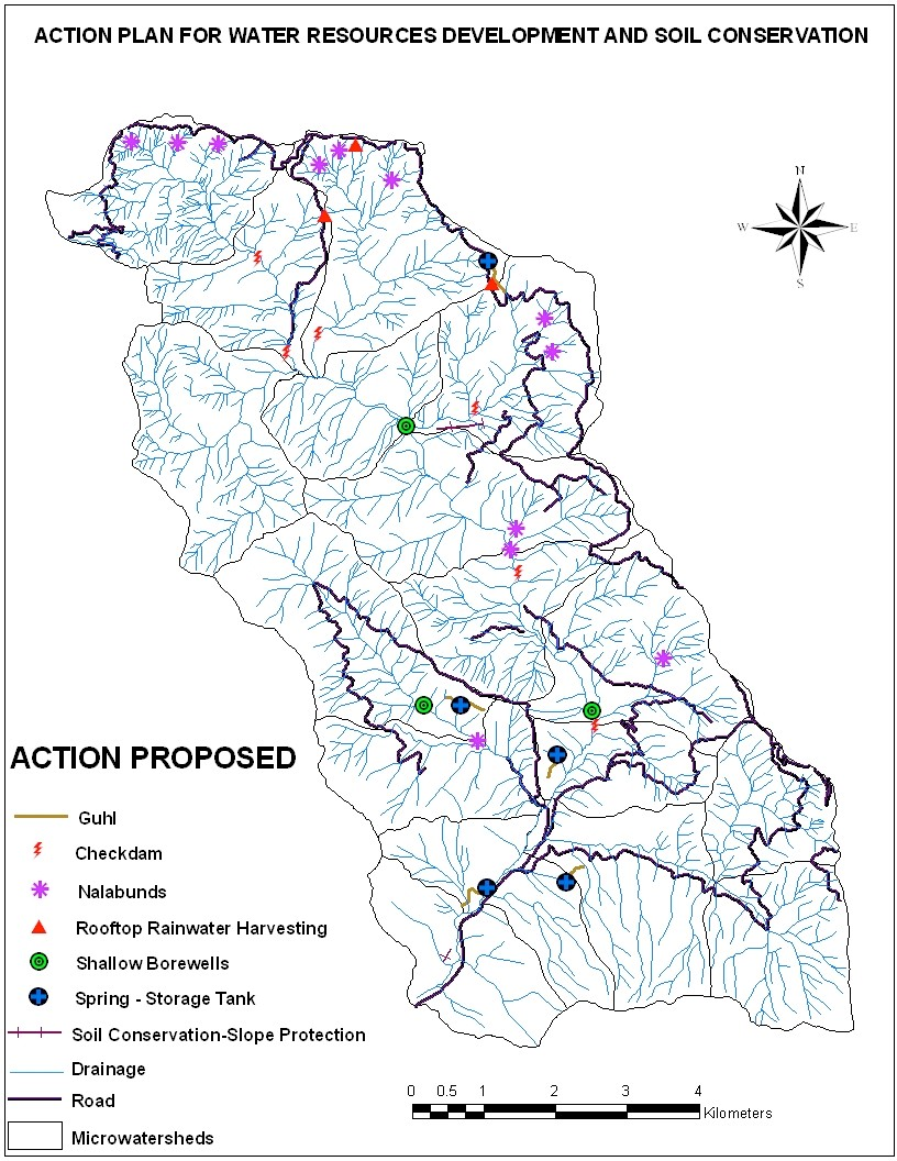
FIGURE – 8: Action plan for water resources development.
RESULTS & DISCUSSION
Agricultural Land
Landuse/Landcover map shown that nearly 19.75 sq km (25.95%) of the watershed area has been used for agricultural purposes, in which double crop covers largest area of 8.25 sq km (10.84%). The area of agriculture under Kharif crop is nearly 7.4 sq km (9.72%). The Rabi only cropland occupied nearly
3.27 sq km (4.29%). The fellow land has been mapped nearly 0.83 sq km (1.09%) area of watershed. The agricultural area divided into two categories: first is with tree and other one is without tree cover. Out of total area under agriculture land, with tree cover occupied nearly 2.58 sq km (double crop with tree 1.53 sq km, kharif crop with tree 0.79 sq km, rabi crop with tree 0.63 sq km and fellow land with tree 0.22 sq km), and the remaining area is nearly 17.17 sq km (double crop without tree 6.72 sq km, kharif crop without tree 6.61 sq km, rabi crop without tree 2.64 sq km and fallow land without tree 0.61 sq km) marked under agriculture without tree.
Forest Land
In the total area of watershed, the largest area covered by forest. The forest area classified in different classes under high altitude oak, mixed oak, low altitude oak, pine forest and the density of forest like as dense, moderately dense, open and scrub/degraded forest. An area of nearly 29.67 (38.85%) marked under total forest covered area in watershed. The high altitude oak covered 5.46 sq km (7.15%) area, in which high altitude oak dense forest covered 1.59 sq km (2.08%), high altitude oak moderately dense covered 1.39 sq km (1.82%), high altitude oak open forest covered 0.77 sq km (1.01%), and high altitude oak scrub/degraded forest covered 1.71 sq km (2.24%) area. The mixed oak covered an area nearly 7.91 sq km (10.41%), in which mixed oak dense covered 3.12 sq km (4.09%), mixed oak moderately dense covered 1.34 sq km (1.77%), mixed oak open covered 1.16 sq km (1.53%) and mixed oak scrub/degraded forest covered 2.29 sq km (3.01%) area. The low altitude oak covered area nearly 7.92 sq km (10.42%), in which low altitude oak dense covered 4.19 sq km (5.51%), low altitude oak moderately dense covered 1.22 sq km (1.61%), low altitude oak open covered 1.03 sq km (1.35%) and low altitude oak scrub/degraded forest covered 1.48 sq km (1.95%) area. An area nearly 8.28 sq km (10.9%) marked under pine forest, in which pine dense forest covered 4.48 sq km (5.89%), pine forest moderately dense covered 0.96 sq km (1.275), pine open forest covered 1.13 sq km (1.49%) and pine forest scrub/degraded covered 1.71 sq km (2.25%) area.
Non-Forest Area
Non-forest area marked under those areas which are outside the forest land. These areas as tree clad, grass land, dense scrub, open scrub and settlement areas. An area nearly 26.78 sq km (35.19%) marked under non-forest area, in which tree clad covered about 0.66 sq km (0.87%)area, scrub land covered
25.19 sq km (33.11%) area {dense scrub
4.65 sq km (6.11%) and open scrub
20.54 sq km (26.99%)}. The grass land occurs only 0.65 sq km (0.85%) area and nearly 0.28 sq km (0.37%) area marked under settlement.
Table 2. Land Use/ Land Cover Classification Statistics.
|
LULC |
Area (sq km.) |
Area (%) | ||
| Level-1 | Level-2 | Level-3 | ||
| Agriculture | Double crop | with tree or without tree | 8.25 | 10.84 |
| Rabi only | with tree or without tree | 3.27 | 4.3 | |
| Kharif only | with tree or without tree | 7.4 | 9.71 | |
|
Fallow |
with tree or without tree |
0.83 |
1.09 |
|
| Forest | High Altitude Oak | Dense | 1.59 | 2.08 |
| High Altitude Oak | Moderately Dense | 1.39 | 1.82 | |
| High Altitude Oak | Open | 0.77 | 1.01 | |
| High Altitude Oak | Scrub/ Degraded | 1.71 | 2.24 | |
| Mixed Oak | Dense | 3.12 | 4.09 | |
| Mixed Oak | Moderately Dense | 1.34 | 1.77 | |
| Mixed Oak | Open | 1.16 | 1.53 | |
|
Mixed Oak |
Scrub/ Degraded |
2.29 |
3.01 |
|
| Low Altitude Oak | Dense | 4.19 | 5.51 | |
|
Low Altitude Oak |
Moderately Dense |
1.22 |
1.61 |
|
| Low Altitude Oak | Open | 1.03 | 1.35 | |
| Low Altitude Oak | Scrub/ Degraded | 1.48 | 1.95 | |
| Pine forest | Dense | 4.48 | 5.89 | |
| Pine forest | Moderately Dense | 0.96 | 1.27 | |
| Pine forest | Open | 1.13 | 1.49 | |
|
Pine forest |
Scrub/ Degraded |
1.71 |
2.25 |
|
| Non-Forest | Grassland | 0.65 | 0.85 | |
| Tree clad | 0.66 | 0.87 | ||
|
Scrubland |
Dense |
4.65 |
6.11 |
|
| Open | 20.54 | 26.99 | ||
| Settlement | 0.28 | 0.37 | ||
| Total | 76.1 sq km | 100.00 % | ||
ACTION PLAN GENERATION/PROPOSED ACTIVITIES FOR NAGANI WATERSHED
In the present study, after the integration of all above parameters or thematic maps, two action plan have been suggested for Nagani watershed are as follows:
-Land Resources Development Plan.
-Water Resources Development and Soil conservation Plan.
Land Resources Development Plan
Based upon the study of land use, geomorphology, soils, ground water, rainfall, slope/aspect, altitude, socio- economic data and irrigation facilities available in the area, a package of land use practices has been recommended for land resources management on a long-term basis. The basis for these development packages can be grouped under two heads:
Environmental factors: Landform, Slope/aspect, Altitude, Soil, Rainfall etc.
Human Induced factors: Land use, Approachability by road, Irrigation practices, Agricultural practices etc.
The action plan for land resources management has been discussed under the following heads:
- Management of Forest land
- Management of Agricultural lands
- Management of Wastelands
Management of Forest Land
Most of the energy needs of villages in Himalayan region is met through forests, which has led to gradual depletion of forest canopies ultimately resulting into open/degraded forests or scrub land. Two major actions have been suggested for management of forested land
- Plantation (afforestation) and (ii) Gap filling. The scrub/degraded forests are considered for afforestation and open forest for gap The species for afforestation has been suggested based on their local suitability and potential need of neighboring villages.
Afforestation
Since, the local population depends on forests to meet their fuel and fodder needs; there has been a gradual depletion of forest wealth in the Himalaya, in general. Afforestation is thus essential for the sustainability of Himalayan Ecosystems. The scrub/degraded forests are potential areas for carrying out afforestation. The afforestation of various species is suggested based on their suitability to the area as well as potential needs of neighboring population.
Management of Agricultural Land
Agriculture in Himalayan area is not considered economically efficient due to low agricultural production. Thus, there is a need to have a relook on the agriculture for improvement of productivity. The agricultural land without trees is recommended for agro-forestry or agro-horticultural plantations based on site suitability.
Agro-Forestry/Agro-Horticulture
Major consideration for suggesting agro-forestry systems is to produce fuel and fodder for local needs, in addition to agricultural crop. Agro-horticulture may be adopted on arable lands having fruit tree, which provides higher income per unit area and are suggested on upland areas and hill slopes with staggered contour trenches. Agro-horticultural practices are suggested for the terraces with slopes facing east or west, where the shadow of fruit trees is expected to fall along terrace slope, not on the main crop land. In the fellow land which have irrigation facilities and soil fertility for crop production, agro-horticulture have been suggested for these areas. Double crop recommended for those areas which rise kharif only crop or Rabi only crop but they occurs along the streams or nearly of streams, and in these areas irrigation facilities can be improve, those areas have been suggested for double crop.
Management of Waste Land
Wastelands in the study area can be put under productive use by following means:
Silvipasture/Afforestation/ Horticulture
The degraded areas in erratic rainfall areas are suggested for silvipastures, which consist of fuel tree species long with grass or legumes. The silvipasture systems in the area are expected to fulfill the fuel wood and fodder needs of villages. However, it is advised to not to allow grazing in the areas. Grasses and legumes should be harvested and stall fed.
Wastelands occurring outside the notified boundaries of forest land are suggested to be put under forest plantations. Species for afforestation are suggested earlier under the head ‘management of forest land’. Afforestation is proposed in forest blanks/open forest areas to increase the density of vegetation, to control soil erosion, check runoff etc. Agro-forestry/soil-forestry is recommended on hill slopes, which also help in soil and water conservation.
Scrub lands near agricultural lands with feasibility of transportation to market and having suitability for growth of fruit trees are recommended to be put under horticultural plantation.
Grass land Protection
Grass land protection recommended for grass land areas. In the summer season generally forest areas or grass land areas suffer from fire, so fire protection and management also recommended for grass land areas
Table – 3: Proposed activity for land resources development
| Sl. No. | Activity Proposed | Area (sq km.) | Area (%) |
| 1 | Plantation of Mixed Species | 1.15 | 1.52 |
| 2 | Plantation of Oak associated Species | 1.78 | 2.34 |
| 3 | Plantation of Pine associated Species | 1.13 | 1.49 |
| 4 | Gap filling with Mixed Species | 2.29 | 3.01 |
| 5 | Gap filling with Oak | 3.12 | 4.09 |
| 6 | Gap filling with Pine | 1.69 | 2.22 |
| 7 | Crop land, Agro-Horticulture’ | 0.91 | 1.18 |
| 8 | Double Crop | 7.55 | 9.93 |
| 9 | Silvipasture | 24.96 | 32.79 |
| 10 | Grass land management | 0.65 | 0.86 |
| 11 | No Activity Proposed | 30.87 | 40.57 |
| Total | 76.1 sq km | 100.00 % | |
Water Resources Development & Soil Conservation Plan
Water resources development action plan has been generated on the basis of integration of information on drainage, landuse/vegetation, hydrogeomorphological characteristics, slope, surface and ground water exploitation and keeping in view the immediate and long term needs of water in the area. The water resources development and soil conservation action plan map shows areas recommended for ground water exploitation on the basis of groundwater potential of the terrain, suggested locations of structures for harnessing surface water resources and various soil conservation measures on hill slopes, along roads and on streams.
The problem related to water resources development and soil conservation activities that need to be addressed in Nagani watershed are as follows:
– The main constraint for the development of the region is unfavorable terrain condition.
- Degradation of vegetation cover due to biotic
- Scarcity of water for domestic and irrigation
- Steeply sloping hills, slope instability and depleted vegetation cover
- causing high runoff and soil
- Recurrence of landslide and slips on unstable
- Uneconomical agricultural
- Diminishing discharges in
Ground Water Resources Development
To increase crop lands, horticulture and nurseries, ground water exploration have been suggested. The ground water is a major source for irrigation of agricultural land. Interspaces in horticulture plantation may be possible grown with vegetables on agricultural land.
Surface Water Resources Development
Construction of water harvesting structure in hilly terrain along stream not
- d) Roof-top rain harvesting
Check Dams
Check dams are proposed across the stream to tap the stream water for irrigation or drinking water purposes. The check dams have been recommended at various sites after analyzing the nature and order of the stream, topography, soil and landuse conditions. Following points were considered while recommending a site suitable for constructing check dams:
- Preferably constructed on 2nd or higher order stream which is perennial in nature as it will ensure adequate water supply during all
only retards the runoff velocity but also helps in its useful utilization. Besides, it also checks the sediment flow which may choke the large structures located downstream. Additionally, the water available from springs (Dharas) and surface seepages (Naulas) can also be tapped efficiently with their proper maintenance. Rainwater harvesting has also been suggested under this section.
Following actions have been recommended for harnessing surface water in Nagani watershed.
- Check dams
- Springs storage tank
- Guhl
- Availability of narrow valley with a relatively low bed gradient upstream of the structure to allow formation of a In the absence of sufficiently low gradient area for the reservoir across the stream the water can be diverted from the structure to a reservoir (tank) constructed at suitable location away from the structure.
-Beneficiaries (settlement and agricultural lands) should be located downstream close to the structure such that stored water can be supplied through gravity fed guhls/canals/pipelines so as to reduce the cost of delivery system.
-Availability of good construction material from nearby regions.
-Geologically, the banks should have hard rocks and free from landslides.
-People’s participation for maintenance of structure, delivery system and for water scheduling.
-The location marked for check dams in the map are approximate, and exact locations may be ascertained keeping in view the actual conditions.
Springs Storage Tank
In Nagani watershed and surrounding hills a number of springs are present. Some of them have good discharges. However, it has been recorded that the spring discharges are gradually getting depleted and some of them almost dry out during summer. In order to properly exploit the springs during high discharges and to arrest further reduction in discharge, the following measures are recommended:
- Construction of multiple storage tanks to collect the spring These tanks can be away from the mouth of the springs at convenient locations. Water can be distributed from these tanks though pipes or guhls. The number and size of the tank depend on the availability of water from the springs and the locations.
-Periodic cleaning up of the mouth of the spring.
-Identify the spring catchment area and maintain it as a sanctuary to prevent human interference, biological
degradation and cattle grazing. Deep rooted, soil binding and moisture conserving grasses and plants are to be maintained in the catchment area.
Guhl
Guhl has been suggested along the contour line or depression land for the purpose of improving irrigation facilities or drinking water. The guhl mainly used by farmer in valley areas for irrigation purposes.. Guhl use for supply of water for irrigation from spring storage tanks by using pipeline or soil grazing along the contour line.
Rooftop Rainwater Harvesting
Rooftop rainwater harvesting is increasingly being followed for meeting the domestic water needs of rural areas in hill regions. It has been recommended for the villages in Nagani watershed, in Tehri-Garhwal district, which are located at or near the ridge and for which only limited source of water is available. There are many methods for harvesting rain water and they are site specific. Following steps are essentially involved in rainwater harvesting from roofs:
- Collection of rainwater
- Separation of first rain flush
- Filtration of rain water
- Storage of rain water
The rainwater which falls on the sloping slate-roof can be channelized through a collector to divert dirty water and to check sediment flow to the storage tank.
Soil Conservation Activities
Importance of soil conservation in arresting soil and land degradation has been recognized. Soil erosion severally affects hilly areas because of the steep slopes. Landslides and slips are other problems of hilly areas. Following measures can be recommended under soil conservation activities:
- Nalabunds
- Stream bank protection
- Landslide stabilization
- Roadside slope protection
Nalabunds
Nala bunds are useful: (a) to collect soil and water to ensure the eventual growth of protective vegetation and (b) to check channel erosion until sufficient stabilizing vegetation can be established. They can be constructed from locally available material e.g., brushwood, poles, woven, wire, loose rock etc.
Nala bunds have been recommended across the streams at various sites on the basis of topographical slope, landuse, drainage, and soil characteristics. Following criteria have been adopted for selecting site for nala bunds:
- Drainage : Its or 2nd order ephemeral stream; narrow bed width and low bed gradient.
- Topographical slope : > 15 %
- Land use : Land with or without scrub,
- Soil properties : Coarse loamy to skeletal
For all above proposed actions, field checks (Ground truth) are required.
Soil Erosion Control
Vegetative Barriers: These are closely spaced gram hedges or plantation usually a furrow of grasses or shrubs grown along the contours with gross for erosion controls in agricultural lands. They are suitable for arresting runoff and erosion control in relatively flat and slight undulating topography.
Contour Bunds: These structures control the effective length of slope and thereby reduce the gain in velocity of runoff flow to avoid Rill and gully formations. These are suggested for moderate slopes and where the rainfall is less than 600 mm annually. Where the annual is greater than 600 mm, graded bonding is recommended.
Contour Trenching: These are made in uncultivable lands having silvipasture or agro-horticulture and slope ranging 5- 15% (moderate slopes).
Cultivation and Gully Plugging: These are suggested at higher slopes, mainly to retain more rain water and to increase the infiltration by cultivating along the contours. These are quite effective in reducing soil erosion.
Plugging or Earthen Embankments:
These are usually constructed for blocking the active and erosion prone gullies for their stabilization and are constructed across small and medium gullies, particularly where rate of runoff is low. Generally, these are constructed with locally available rock for gully plugging.
Table 4: Action plan for Water Resources Development and Soil Conservation
| S.
No. |
Activity | Number of locations |
| 1 | Guhl | 9 |
| 2 | Check dams | 6 |
| 3 | Nala bunds | 12 |
| 4 | Rooftop Spring storage tank | 3 |
| 5 | Shallow bore wells | 3 |
| 6 | Spring storage tank | 5 |
| 7 | Soil Cons./Slope protection | 2 |
Note : These are typical sites given on the basis of topography, drainage, slope and present land cover. The exact number of sites and their locations are to be decided on the basis of actual ground conditions and requirement.
CONCLUSION
The present study has been carried out for the Nagani-river watershed using geospatial techniques. The objectives of the present study were to find out different parameters of watershed, generate various thematic maps and propose activities for land and water resources development and soil conservation for watershed area. In this study, various thematic layers have been prepared such as slope/aspect map, watershed boundary layer, micro- watersheds boundary layer, base map, drainage map, etc. for integration of these layers and generation of final landuse/landcover map and suitable action plan maps for land resources development and water resources development plan for watershed areas. Amongst the land use/land cover classes of the watershed, largest area is covered by forest and open scrub. Various types of forest cover found in the watershed are mixed forest, oak forest and pine forest. Amongst the land under agriculture, kharif crop production is higher then rabi crop. Some of the watershed area have been marked under tree clad, grass land and settlement.
In this study, two action plans have been generated for land and water resources management. Under land resources activities, plantation of mixed species, plantation of oak associated species and plantation of pine species have been suggested for open forest areas and gap filling with above species suggested for scrub/degraded forest, respectively. The scrub land region of watershed has been suggested for silvipasture activity. Protection of grass land areas have been suggested as they are highly prone to forest fire. Similar action has also been suggested for pine region. The single crop areas which are along streams have suggested for conversion to double crop wherever irrigation augmentation is feasible. Fallow land has been suggested for utilization towards crop land or under agro-horticulture. In other area of watershed no activity has been proposed. For the water resources development and soil conservation plan following activities proposed:
- Guhl
- Check dams
- Nalabunds
- Rooftop Spring Storage tank
- Springs storage tank
- Soil conservation/slope
REFERENCES
T. CHANG (2004), “Introduction to Geographic Information Systems”, Tata McGraw-Hill Publishing Company Ltd. New Delhi.
RAVI GUPTA (1991), “Remote Sensing in Geology”, Springer- Verlag Berlin Heidelberg New York.
LILLESAND, THOMASH and KIEFER RALPH W. (2004) –“Remote Sensing and Image Interpretation”, John Wiley & Sons, Inc
RAGHAVA RANI and M. ANJI REDDY (Dec-2002), “integrated Approach for Sakalapally Watershed Management using Remote Sensing and GIS”, B S Publications, Sultan Bazaar, Hyderabad (A. P.), Pp.- 493-502, Vol-II,
M. RANADE (2003), “Genesis and Performance of Evaluation of Watershed Development Works in India – with Specific Reference to Peninsular Drought Prone Area”, Published by- Association of Hydrologists of India and Andhra University, Visakhapatnam, India, Pp. – 27-35, Vol-16, “Journal of Applied Hydrology”, Editor- V. V. Jagannadha Sarma.
DWIVEDI, S. (1993), The Role of Remote Sensing in watershed management”. Asian-Pacific Remote Sensing JI, vol-6, no-1
SURESH, R. (2000), “Soil and rd Protection Water Conservation Engineering” 3Ed.“Watershed-Concept and Management”, Pp. 785-813.
TIDEMAN, M – “Watershed Management – Guidelines for Indian conditions. Omega Scientific Publishers, New Delhi.
N. ROY – “Participatory Remote Sensing and GIS for Micro Level Watershed Planning and Management”, National Institute of Technical Teachers’ Training and Research, Chandigarh – 160 019, India.
MOHSMED GHOUSE, A. KALYANI, and Y. FARID ALI KHAN “Micro-Watersheds Information System”, Agriculture Engineering Department Chennai-600035, Tamil
K. SHARMA, R. R. NAVALGUND, A. K. PANDEY and K. RAO – “Micro-watershed development plans using Remote Sensing and GIS” for a part of Shetrunji river basin, Bhavnagar district, Gujarat, Space Applications Centre, Ahmedabad, and U. T. D. Barkatullah Vishwa vidhyalaya, Bhopal
K. AGARWAL and T. S. KACHHWAHA (2004), “Water Resources Management Plan in Hilly Terrain Using Large Scale IKONOS Satellite Data”, Remote Sensing Applications Centre, Uttar-Pradesh Sector-G, Jankipuram, Kursi Road, Lucknow.
BOTHALE et al. “Delineation of Eco watershed by Integration of Remote Sensing and GIS Techniques for watershed planning and management of water and land
JAN VAN WAMBEKE – “The Micro watershed as a place for planning the use and management of natural resources, Socio-Territorial approach” Oficial Principal de Desarrollo Tierras y Aguas.
C.JAIN – “Watershed Management – Kerala calling”, July 2004 17, Kerala State Land Use Board, Kerala.
K. SURESH KUMAR et al. (2002) “Micro-level planning for sustainable lad and water management: Bharathamala-Vattakkotta watershed’, Discussion paper no. 46, Kerala Research Programme on local level development, Centre for Development Study, Thiruvananthapuram.
SUVROKAMAL DUTTA et (2007) “Watershed Management – India’s Crying Need”, Views: 8065 Comments: BHUWNESHWAR PRASAD SAH, KIYOSHI HONDA AND SHUNJI MURAI, “Subwatershed Prioritization for Watershed Management using Remote Sensing and GIS” Asian Institute of Technology, P.O. Box 4, Klong Luang, Pathumthani, 12120, Thailand
K. GOSAIN AND SANDHYA RAO (2004) ” GIS-based technologies for watershed management, 948 current science, vol. 87, no. 7.